

Solutions
There aren't any reports to show yet.
Latest News
Case Study
York 2015: Anatomy of a Flood Disaster
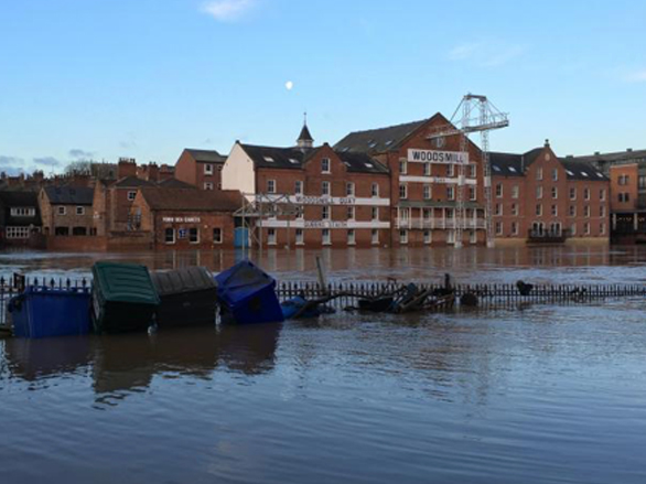
York has known devastating flooding many times before and if ever there was a city used to its ravages, its residents have felt it. Time and again, the city’s defences have been improved and adjusted, as new lessons have been learned – but Christmas 2015 raised the bar once again. Over the course of a few days, York suffered its worst flooding in a generation.
Main Image: The Ouse on December 29. Picture: Steve Carroll
Storm Eva unleashed a wave of unprecedented rainfall across the north. Coming just three weeks after Storm Desmond, it exacerbated the ongoing situation, with saturated river catchments responding swiftly to the new deluge.
York Flood Group – made up of the City of York Council, the Environment Agency, North Yorkshire Police, North Yorkshire Fire & Rescue and Yorkshire Water – met on December 27 to discuss the worsening situation. The group usually meets only when the River Ouse levels reach, or are expected to reach, 4.2 meters above normal summer level (asl).
On Monday 28 December, the Ouse peaked at 5.2 metres above its normal summer level, just short of the all-time high of 5.4 metres, recorded in autumn 2000. However, city-wide flooding occurred due to the devastating failure of the Foss Barrier.
It was opened on Saturday 26 December after the pumping station was flooded, leading to floodwaters from the Ouse flowing back into the Foss. The primary concern was the pumps failing due to water ingress to the electrical supply.
The Environment Agency said that if the Foss Barrier were not lifted, it could have jammed in the closed position, causing even worse flooding for 1,800 properties, as water would not have been able to discharge into the River Ouse.
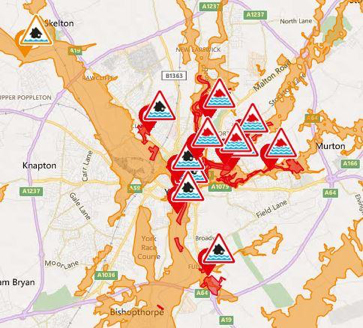
As a result of the decision, huge areas were flooded for the first time in many people’s lifetimes. Foss Islands Road was closed, Foss Bank and the river were indistinguishable, and several cars parked off Layerthorpe were almost completely submerged.
About 500 homes alongside the Ouse, the Foss, Tang Hall Beck and Osbaldwick Beck were inundated. James Street travellers’ site was also severely hit, with many distraught residents saying they had lost everything.
In total in York, 250 people were evacuated from their homes. Around 10,000 sandbags were used, with 600 military personnel, 125 mountain rescue members, York Rescue Boat teams and countless volunteers helping to rescue flood victims or to fill and distribute sandbags around the flooded areas.
By December 29, the Foss barrier was operational again. The army flew in emergency equipment the day before and repairs were carried out overnight, but by then it was too late for many.
Householders were left counting the cost and many business owners in the city-centre said they were given no warning the barrier was being lifted.
In total in York, 250 people were evacuated from their homes. Around 10,000 sandbags were used, with 600 military personnel, 125 mountain rescue members, York Rescue Boat teams and countless volunteers helping to rescue flood victims or to fill and distribute sandbags around the flooded areas.
At its height, the flooding caused major knock-on problems.
Floodwaters swamped the basement of the BT telephone exchange, damaging electrical equipment and cutting landline and wi-fi broadband services for thousands of York customers.
People across the city lost phone and internet connections, and many mobile networks failed or struggled, with some people unable to make or receive calls.
Many buildings in the city-centre had no internet or phone connections and most shops, pubs and cafes were able to take cash payments only, as card machines were down.
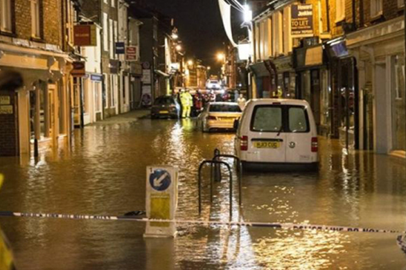
Picture courtesy of Alfio Fresta
The Jorvik Viking Centre flooded for the first time in its 31-year history, and faced a closure of up to a year. The cells at York Magistrates Court also flooded, meaning many cases had to be moved to other courts.
North Yorkshire Fire and Rescue’s High Volume Pump from Harrogate was used at the Melrosegate Electrical Sub Station to keep it going, preventing 55,000 customers from losing power.
In the end, around 650 homes and businesses had been directly affected by flooding in the city centre. The cleanup cost the council half a million pounds, excluding damage to council assets including properties and infrastructure. It persuaded the government to pay £17m for Foss Barrier improvements and £45m for wider flood risk management improvement works across the city.
The original Foss pumping station was designed to pump about 30 tonnes of water per second from the Foss into the Ouse and was clearly unable to deal with the demand that Christmas.
The upgrade, which will include the installation of eight more powerful replacement pumps, is set to increase its capacity so it can handle at least 40 tonnes per second – securing its performance for the foreseeable future – or until climate change raises the bar again.
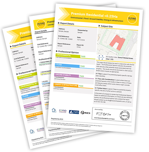
Future Climate Info provides a comprehensive flood risk assessment for residential properties through its suite of Environmental Risk Reports. These account for river, sea, coastal and surface water flood extents for a full, clear and effective view on any potential risks ahead of a property transaction.
Based on the assessment, Specialist flood risk services can look at flood resilience measures and a review of flood zoning with climate change allowances can give an accurate appraisal of the likelihood of flooding into the future.
For more information, contact us on 01732 755180 or email info@futureclimateinfo.com
2015 Leeds Commercial Property Flooding: Towards Better Resilience
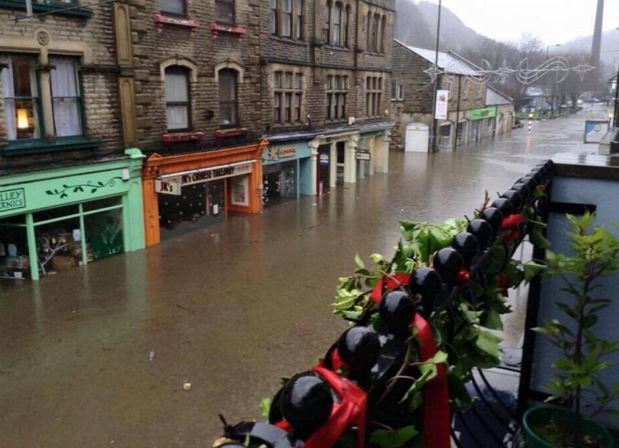
It was a day most people in Leeds did not see coming, and one the business community in the city may never forget.
Kirkstall Road, one of the main commercial streets in the city, was completely submerged under murky rainwater after a un-precedented downpour on Boxing Day 2015 from Storm Eva.
Leeds experienced significant and widespread flooding from some of the highest river levels ever recorded. The flooding was centred on the commercial/industrial area along the A65 Kirkstall Road and Stourton to the south of Leeds railway station.
Devastated business owners and residents paid the price – the deluge battered 3,355 properties in Leeds, 672 of which were businesses.
Before this event, the closest comparison was in 2000 when around 100 properties in the city flooded.
As shops, restaurants and bars prepared for a bustling Boxing Day, the Environment Agency issued a red warning – its highest alert, signalling “significant impacts to infrastructure and risk to life in the area”.
Parts of the city centre, including Sovereign Street, The Calls and Clarence Dock, felt the full force of the deluge as the evening wore on.
The River Aire at Crown Point, which is usually 0.9 metres high, rose to 2.95 metres at 1am on December 27. Its previous high was 2.45 metres, recorded in June 2007.
Businesses Disrupted and Lost
Tyrannosaurus Pets, a specialist reptile shop on Kirkstall Road, was one business hit hard by the floods. They had animals in the basement, which the business owners rescued and moved upstairs as water was coming in through the door.
It re-opened more than eight months later during the August Bank Holiday at a temporary location in Headingley. But parking was a major problem and the business lost trade while it was forced to relocate.
The owner Matthew Pedder admitted that after a year away from their shop, it had been very painful. He knew of another firm down the Kirkstall Road that had put all of their life savings into a business and open two months before the floods only to see them lose everything.
Ultimately, the direct cost to the city was an estimated £36.8m, with the cost to the wider city region being more than £500m, according to Leeds City Council.
Building Better Commercial Resilience
It was a wake-up call to protect the commercial heart of England’s fourth largest city. It had already spent £50m on a flood alleviation scheme which had started the year before covering three miles of river bank from Leeds train station to Kirkstall. This was the first time that flood defences had been placed along the River Aire.
It was one of the largest river flood alleviation schemes in the country, designed to provide increased protection to more than 3,000 homes, 500 business and 300 acres of development land.
But it clearly wasn’t enough…
Now, a second stage to the scheme is being proposed, which if the green light is given for the £112m investment, will see more ,measures being implemented along the Aire to Calverley.
The difference with Phase 2 will be a catchment-wide approach, adopting a combination of Natural Flood Management (NFM) and engineered measures to help slow the flow and catch water further up the catchment so that flood peaks are reduced further downstream.
The Phase 2 plans have a strong focus on NFM, with proposals to create new woodland areas with some 2 million new trees planted, doubling the canopy coverage in the River Aire catchment.
Water storage areas will be created and developed, operated by a control gate system meaning water can be held and then released back into the river when safe to do so. A third element would be the removal of existing obstructions along the river to help reduce water levels, along with lowering the riverbed in places to improve its capacity and flow.
The intent is to deliver NFM works over the next 30 years with the aim of sustaining the standard of protection in the face of climate change up to 2069. This would also involve:
- land management to reduce surface water run off;
- river and flood plain restoration including re-meandering of the river channel in certain areas and smaller storage ponds;
- where possible, using sites in Leeds to store flood waters when river levels are high. Current proposals include a site upstream at Calverley;
- improving the flow of water through the city with the removal of redundant bridges and widening the river channel adjacent to the A65;
- improving riverbank protection measures with enhanced woodland areas and installing debris dams;
- constructing raised defences along the river which could include landscaping, terracing, embankments and walls.
The aim is to achieve a 1 in 200 year standard of protection, but initial funding looks likely to go for a one-in-100-year level of protection using government funding supported by council and other financial support.
Commerce vulnerable to future flood risk
Leeds demonstrates how behind the curve we still are with regard to protecting our commercial infrastructure in the face of ever more extreme rainfall events. It’s not alone as a city facing these problems. Leeds has a major river running through it and therefore the focus is managing the fluvial flow. It is far harder when you have surface water events from a local deluge.
Another example where flood history has and will continue to affect commercial business includes Sheffield, where repeated flood events have been a principal reason for the proposed HS2 route to be diverted away to the east of the City.
Business disruption through flooding is one of the single biggest issues facing commercial property owners or those looking for suitable premises.
Future Climate Info provides a comprehensive flood risk assessment for commercial properties through its FCI Commercial Report. This accounts for river, sea, coastal and surface water flood extents for a full, clear and effective view on risks ahead of the transaction.
Based on the assessment, Specialist flood risk services can look at flood resilience measures and a review of flood zoning with climate change allowances can give an accurate appraisal of the likelihood of flooding into the future.
For more information, contact us on 01732 755180 or email info@futureclimateinfo.com
HS2 set to devastate South Yorkshire neighbourhood
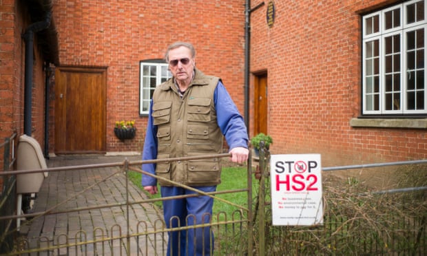
More than 130 families living on the Shimmer estate in Mexborough, South Yorkshire, may have to leave their homes after the government decided that the HS2 train line should go right through their neighbourhood. Some only moved in days before the route was proposed.
They are among 540 homeowners within 100 metres of the new Yorkshire leg of the line who potentially face being forced out of their homes, according to research by the Yorkshire HS2 action groups, who oppose the route.
The campaigners argue that an earlier proposal, which would have seen the line go to Meadowhall shopping centre, north-east of the city centre, rather than follow the M18 motorway to the city centre, would have resulted in only 296 residential demolitions.
The Government has said that 16 of 216 homes on the Shimmer housing estate will be demolished, but residents dispute that figure. Also, the compensation package offered may not allow some Shimmer homeowners to acquire a similar property in the local area.
House prices on the estate have already dropped by an average of 10% of their original purchase prices, according to Carter Jonas. Consultants found that a shortage of similar new-build properties in the surrounding area could lead to price inflation as ousted Shimmer residents bid against each other.
At the time the route was announced, 130 houses had been sold on the estate, with a further 90 properties either built or unsold or yet to be built. All homeowners can now apply for the government to buy their properties at the “HS2 unblighted” market rate, plus 10% compensation and moving costs.
At the sharp end though are those properties not considered for demolition but are so close to the line anyway. Peter and Sue Douglas bought their house on the estate for £165,000 in 2014 and spent two years doing it up for their retirement.

Their home is only five metres from the proposed viaduct, so is not included in the 16 definitely facing the bulldozers and may not get government to buy their home and pay compensation.
Because the estate has never been finished (because of uncertainty over HS2) the houses will be undervalued and they face years of protracted negotiations.
Picture courtesy of Thomas Temple
Leicestershire Wind Farm

Plans for a controversial 150ft high wind turbine at Thorpe Satchville near Melton Mowbray, Leicestershire have been passed four years after it was built – marking the end to a protracted and agonising planning dispute that has plagued the village for years.
The application for the 46 metre (150 ft) tall wind turbine was first submitted in 2012 and blocked by Melton Borough Council, on the grounds of unacceptable landscape harm. But permission was granted on appeal a year later by a government inspector and the turbine was subsequently erected.
Eric Pickles’, the then Secretary of State for Communities and Local Government (DCLG) refused the turbine after planning appeal decisions were called in.
This decision was reinforced 2 years later in 2015, when Pickles’ successor Secretary Greg Clark overturned the inspector’s decision and blocked – abd yet after that, a subsequent appeal was overruled and Clarks’ decision was quashed by the High Court.
The council’s current emerging Local Plan, which is currently the subject of a public examination, stated that the appeal site was ‘an area of low or low to moderate sensitivity to wind turbine development and turbines of up to 50 metres in height would be acceptable’. Early in 2018, Sajid Javid finally approved it citing “the environmental advantages of the generation of renewable energy and the contribution to cutting greenhouse gas emissions.” and that “it would help diversify farm business, protect employment, provide a sounder financial footing and reduce energy costs.”
Villagers were incensed that such an industrial installation was allowed to be built in an area of unspoilt beauty, when other options already affected by infrastructure, such as along the M1 motorway had not been considered.
The local community now face looking at the looming presence of the wind turbines just a few hundred metres from their homes – an alien feature in the countryside.
Newcastle: New Build Property demolished after Coal Mine Discovery
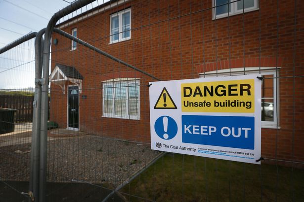
The Bayfield estate in West Allotment, North Tyneside was built by Belllway Homes in 2011 as part of a larger development of several hundred houses on the east side of Newcastle near Shiremoor.
Subsidence and cracking of several homes was first noticed in 2015. Families were originally evacuated in June 2016 and then permanently relocated in January 2017 after severe mining subsidence damage initially threatened five properties, which were initially cordoned off and investigations began to find out the cause of the ground movement.
The Coal Authority set up a base on the estate and carried out detailed examinations over 14 months. Their investigation revealed unrecorded coal mine workings, which date back around 120 years. These showed the site had been extensively worked – usually, in this area, 45% to 50% of coal is mined, but in this case the amount of coal mined was over 70%.
This over extraction resulted in narrow residual supporting coal pillars and wide extraction rooms in the high main coal seam, leading to compression on the remaining coal pillars and roof instability. Together with a weak sandstone layer and fracturing within the rock above the coal seam, this resulted in an underground collapse and subsequent movement of the properties above.
Other potential causes for the ground movement, such as how the properties were designed and constructed, groundwater and the proximity of other quarries, were ruled out so that it was finally identified as an unrecorded mine entry.
In January 2017, five houses on the estate were demolished, with a further 10 scheduled for demolition, costing £95,000, with a total housing development loss of value of around £3 million.
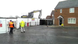
After demolition, stabilisation work could then begin which would allow the area to be redeveloped. Grout was injected into the mine workings to fill the underground cavities and prevent further ground movement. This was followed by six months of further ground monitoring to ensure the ground was stable for redevelopment.
Under the Coal Mining Subsidence Act 1991, The Coal Authority has liability for historic coal mining subsidence claims. These shallow mine workings were not documented by The Coal Authority and the risks were not evident during preliminary due diligence when the land was originally purchased or later when the houses were constructed.
The Authority said, however, that for properties damaged by subsidence, it was only able to consider purchase of homes in cases where the cost of the damage outweighs the cost of repair.
In 2018, the Coal Authority’s Annual Report stated that the damage claim paid out to the homeowners on the Bayfield Estate was “the largest single event we have ever dealt with in our 24 year history.”
Families were distressed throughout, whether through forced evacuation or the uncertainty as to how widespread the subsidence extended and the disruption caused by the demolition and stabilisation of the land.
All of these factors had impacts to local house prices and their enjoyment of their homes. They fear blight and the difficulty of selling their homes even in areas of the estate currently unaffected by subsidence is understandable.

Try before you buy
To take advantage of a trial free order of your first environmental report, please complete the enquiry form and we will get back to you as soon as possible. We will need to take more details of the property or site and ask some more questions about your firm and the transaction.