Paving Paradise? Large Housing Schemes Eating into Green Belt
Local communities and the planning system frequently make very poor bedfellows. If you asked many in the street about whether there should be more house building to solve the country’s acute housing shortage, the answer would be clearly yes. Asked if that new estate should be built in the open fields or at the end of the quiet cul-de-sac where their own house is sat and you would have the polar opposite, always negative reaction.
It is human nature to be resistant to change where that change could disrupt your day to day life – the construction traffic, noise and dirt, to be replaced by rows of windows and bricks where once perhaps was open scenery. This emotion is borne out of buying into something in the first place. As a homebuyer, you are not only investing in the house, its facilities and space, it is about what the future could be and what the sense of place will be like – you assume, forever.
But we all know nothing stays the same and change is constant – and that is why planning permissions for housing development will always remain a potent source of fury.
Two recent approvals on green belt land perfectly underscore this situation.
Pickford Green, Coventry
Coventry City Council has just approved outline planning permission for 2,400 homes on the edge of the city. The land on the 350-acre Eastern Green site was formally designated green belt, but after an independent examination of the Local Plan by the Planning Inspectorate, it was re-assigned and allocated for a Sustainable Urban Extension (SUE) in 2017. The local plan came into force in December 2017 as part of the city’s revised 2011-2031 Plan. The Eastern Green site, between Pickford Green and Allesley Green is one of three SUEs to fulfil the council’s housing targets over the period.
This one decision will have had an immediate financial and emotional impact on residents living along on feeder roads to the south and west of the proposed development site who would inevitably see traffic levels soar from the new housing.
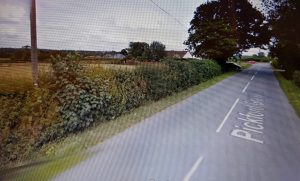
Image of Pickford Green Lane courtesy of Google Earth
The small village of Pickford Green to the north west of the site is already close to the busy A45. In addition to the current road noise, its semi-rural outlook will be transformed by the vast housing estate stretching away to the east and the south, with the inevitable future rat runs of traffic accessing the A45, especially as a new improved junction into the development is promised here.
Either way, it is a far cry from the views of the gently rolling valleys, the hotel and golf course and the variety of footpaths that criss-cross small waterways.
Overdevelopment for overstated population growth?
Countryside campaigners are deeply concerned about the Coventry Local Plan and have called for an immediate review. In total, 24,000 houses in the wider Eastern Green and Keresley area to the west of the city are planned. Two petitions with 7,000 signatures have been recently submitted to the council, supported by a cross-party group of local MPs and Andy Street, the West Midlands Mayor.
They believe that the Office for National Statistics (ONS) projections for population growth that have been used to justify the housing allocation has been “grossly overstated”. Local Councillors are seeking an urgent meeting with the Secretary of State, Robert Jenrick to get a clearer understanding about national housing targets and how they may impact on Coventry’s Local Plan. The plan is not meant to be reviewed until 2022, but this may be pulled forward if the Council can get a signal from the Government to reduce the housing numbers needed.
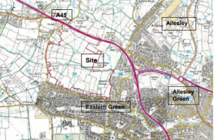
Eastern Green Site Plan, extract from Coventry City Council planning document – Crown Copyright Ordnance Survey, licence number: 0100056489
The approved plans, by Hallam Land Management and the Trustees of the Eastern Green Land Pool Trust, also comprise:
- 15 hectares of employment land (B1, B2 and B8);
- about 10,000 square metres for retail space;
- about 1,000 square metres of local convenience retail plus other community facilities;
- a primary school; and
- open spaces, landscaping, green infrastructure and sports provision.
Out of scale with rural environment?
The site would come with significant community improvements and benefits under a section 106 agreement, but this has done little to quell complaints from other quarters. Highways England have cited inadequate assessment of the strategic road network; the Environment Agency has asserted that the scheme did not take into account climate change allowances; and the Ramblers Association have outlined their fears about the loss of green belt land and access.
But at the heart of this are the residents of Pickford Green – a loose collection of farms, terraced and large detached houses along a quiet country lane. The road has many bends with high hedgerows, currently ill-suited to take the traffic increase. While pylons march across the skyline, they have been part of the fabric for many years and sit in the landscape without too much intrusion. As ever, it is the unknown that causes concern for the residents, wondering whether there will be an impact on their property values and their sense of place, along with the feeling that what was once rural may now become urban.
Hursley, Hampshire
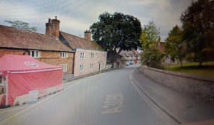
Image of Hursley courtesy of Google Earth
The village of Hursley was considered such a quintessentially English rural landscape, that John Constable painted a series of watercolours here in 1804. This picturesque setting, nestled in the downs to the east of Winchester has a long history dating back to King Alfred and battles with the Danes and more recently as a centre for the development of the Spitfire fighter plane.
The settlement strewn along the main road forms all the classic elements: community shop, butchers, pub and nursery. But this could all change with the proposed “Royaldown” development of 5000 homes, together with new access roads, a primary school , park and ride facility and a health centre, all powered by three solar farms that would surround the site.
The nearby Hursley House where the Spitfire plans were drawn up is a grade II listed mansion with covenants that protect the views across the downs.
Space needed for quality of life
Local MP Steve Brine has questioned the need for the housing numbers in the area, given the amount of development happening close by. Speaking to the Hampshire Chronicle, he said:
‘What locals value is what we call the landscape setting. That is extremely valuable to quality of life and to mental health.
‘These proposals would see Hursley become nothing more than a row of houses, a couple of pubs and a few shops that sit around a very busy road.
‘We will not build back greener and protect our environment by concreting over vast swathes of the Hampshire countryside.’
We reported a while back on the huge expansion of development in neighbouring Eastleigh Council. These combined plans make for a large urban extension in a highly sensitive green belt location but the site, which is owned by a single landowner, is not specifically covered by any national, regional or local landscape designations.
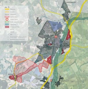
Map extract from Winchester City Council planning documents
The above map shows how the development would extend the fabric of the Winchester urban area to the south west to engulf Hursley. While local businesses may welcome the extra trade from the new households, residents along the main A road will be less pleased to see them driving to and fro with the inevitable rise in noise and air pollution.
Site under assessment or in limbo?
A spokesman for Winchester City Council said: ‘The Royaldown proposal has been submitted as a site for Winchester City Council’s Strategic Housing and Economic Land Availability Assessment (SHEELA) – a process we are required to undertake by the government.
‘A submission to the SHEELA does not mean that the site will or should be developed and the proposal on this site is one of many we are currently assessing.
‘We await clarity from the government on the number of new homes required for our district and will ensure the most suitable sites are allocated for future development in order to meet housing needs.’
Hursley is a classic example of a dormitory village close by a large, successful and rapidly expanding urban area. Without the protection of any designation and with a landowner ready to sell, there is a great temptation for a Council to meet government demand, especially when, on a map at least, the urban extension appears to offer logical in-fill.
This forms part of the double- edged sword that homebuyers need to weigh up and understand. Do you want to buy into a semi-rural piece of paradise and live in fear of it being paved over in future years as the number of households in the area grow out inexorably to meet your once-sleepy village?
A Nationwide Pattern – Happening near your Client
Conveyancers should support their clients, regarding how large scale planning applications and proposals could impact on the value of a property asset well ahead of exchange. This will enable a client to make an informed decision on this and other matters including flooding and contaminated land, as well as the potential traffic issues and loss of visual amenity that could affect their day to day lives after completion.
FCI’s Premium Planning Plus Report pulls “live” planning data at the request of each report, ensuring that the very latest available information is used to compile the product.
Using FCI’s unique intelligent FCICapture technology, we identify developments which, although lying outside of the search boundary, if completed may, in reality, extend within the area of interest around the subject property.
This unique approach combines essential information on contaminated land, flood and ground stability checks to complete full environmental due diligence for your client.
For more information, contact us on 01732 755 180 or email info@futureclimateinfo.com
References:
More than 2,000 homes approved in Coventry
Eastern Green planning document http://planning.coventry.gov.uk/portal/servlets/AttachmentShowServlet?ImageName=1441367
https://www.insidermedia.com/news/midlands/approval-for-thousands-of-homes-and-jobs
https://www.hampshirechronicle.co.uk/news/18874557.royal-5-000-new-homes-near-winchester-hursley/
Try before you buy
To take advantage of a trial free order of your first environmental report, please complete the enquiry form and we will get back to you as soon as possible. We will need to take more details of the property or site and ask some more questions about your firm and the transaction.