York 2015: Anatomy of a Flood Disaster
York has known devastating flooding many times before and if ever there was a city used to its ravages, its residents have felt it. Time and again, the city’s defences have been improved and adjusted, as new lessons have been learned – but Christmas 2015 raised the bar once again. Over the course of a few days, York suffered its worst flooding in a generation.
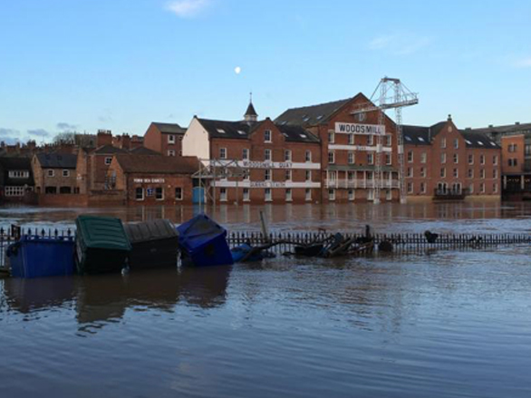
Main Image: The Ouse on December 29. Picture: Steve Carroll
Storm Eva unleashed a wave of unprecedented rainfall across the north. Coming just three weeks after Storm Desmond, it exacerbated the ongoing situation, with saturated river catchments responding swiftly to the new deluge.
York Flood Group – made up of the City of York Council, the Environment Agency, North Yorkshire Police, North Yorkshire Fire & Rescue and Yorkshire Water – met on December 27 to discuss the worsening situation. The group usually meets only when the River Ouse levels reach, or are expected to reach, 4.2 meters above normal summer level (asl).
On Monday 28 December, the Ouse peaked at 5.2 metres above its normal summer level, just short of the all-time high of 5.4 metres, recorded in autumn 2000. However, city-wide flooding occurred due to the devastating failure of the Foss Barrier.
It was opened on Saturday 26 December after the pumping station was flooded, leading to floodwaters from the Ouse flowing back into the Foss. The primary concern was the pumps failing due to water ingress to the electrical supply.
The Environment Agency said that if the Foss Barrier were not lifted, it could have jammed in the closed position, causing even worse flooding for 1,800 properties, as water would not have been able to discharge into the River Ouse.
As a result of the decision, huge areas were flooded for the first time in many people’s lifetimes. Foss Islands Road was closed, Foss Bank and the river were indistinguishable, and several cars parked off Layerthorpe were almost completely submerged.
About 500 homes alongside the Ouse, the Foss, Tang Hall Beck and Osbaldwick Beck were inundated. James Street travellers’ site was also severely hit, with many distraught residents saying they had lost everything.
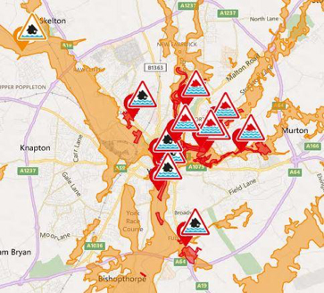
In total in York, 250 people were evacuated from their homes. Around 10,000 sandbags were used, with 600 military personnel, 125 mountain rescue members, York Rescue Boat teams and countless volunteers helping to rescue flood victims or to fill and distribute sandbags around the flooded areas.
By December 29, the Foss barrier was operational again. The army flew in emergency equipment the day before and repairs were carried out overnight, but by then it was too late for many.
Householders were left counting the cost and many business owners in the city-centre said they were given no warning the barrier was being lifted.
In total in York, 250 people were evacuated from their homes. Around 10,000 sandbags were used, with 600 military personnel, 125 mountain rescue members, York Rescue Boat teams and countless volunteers helping to rescue flood victims or to fill and distribute sandbags around the flooded areas.
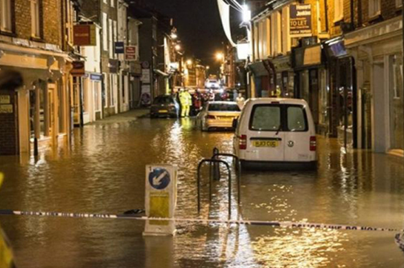
At its height, the flooding caused major knock-on problems.
Floodwaters swamped the basement of the BT telephone exchange, damaging electrical equipment and cutting landline and wi-fi broadband services for thousands of York customers.
People across the city lost phone and internet connections, and many mobile networks failed or struggled, with some people unable to make or receive calls.
Many buildings in the city-centre had no internet or phone connections and most shops, pubs and cafes were able to take cash payments only, as card machines were down.
Picture courtesy of Alfio Fresta
The Jorvik Viking Centre flooded for the first time in its 31-year history, and faced a closure of up to a year. The cells at York Magistrates Court also flooded, meaning many cases had to be moved to other courts.
North Yorkshire Fire and Rescue’s High Volume Pump from Harrogate was used at the Melrosegate Electrical Sub Station to keep it going, preventing 55,000 customers from losing power.
In the end, around 650 homes and businesses had been directly affected by flooding in the city centre. The cleanup cost the council half a million pounds, excluding damage to council assets including properties and infrastructure. It persuaded the government to pay £17m for Foss Barrier improvements and £45m for wider flood risk management improvement works across the city.
The original Foss pumping station was designed to pump about 30 tonnes of water per second from the Foss into the Ouse and was clearly unable to deal with the demand that Christmas.
The upgrade, which will include the installation of eight more powerful replacement pumps, is set to increase its capacity so it can handle at least 40 tonnes per second – securing its performance for the foreseeable future – or until climate change raises the bar again.
Future Climate Info provides a comprehensive flood risk assessment for residential properties through its suite of Environmental Risk Reports. These account for river, sea, coastal and surface water flood extents for a full, clear and effective view on any potential risks ahead of a property transaction.
Based on the assessment, Specialist flood risk services can look at flood resilience measures and a review of flood zoning with climate change allowances can give an accurate appraisal of the likelihood of flooding into the future.
For more information, contact us on 01732 755180 or email info@futureclimateinfo.com
Try before you buy
To take advantage of a trial free order of your first environmental report, please complete the enquiry form and we will get back to you as soon as possible. We will need to take more details of the property or site and ask some more questions about your firm and the transaction.